Thank you for visiting! Here you will find a selection of printable, interactive worksheets for your classroom: Basic Geography worksheets with simple maps, ESL, Spanish, Bible, Reading Comprehension and more. I hope you find the resources useful! Reviews are welcome and very much appreciated. Thank you so much.
Thank you for visiting! Here you will find a selection of printable, interactive worksheets for your classroom: Basic Geography worksheets with simple maps, ESL, Spanish, Bible, Reading Comprehension and more. I hope you find the resources useful! Reviews are welcome and very much appreciated. Thank you so much.
Introduce your learners to AUSTRIA with two worksheets (plus answer key). Your students will read a brief introduction to Austria (location, capital, flag, language), write ‘Vienna’ next to the star on the map to show the location of the capital, color the small map and flag, and use the map and compass to answer 7 questions on page 2. Colored pencils and a pen or pencil are needed for this activity. No other prep needed. Basic Geography worksheet with a simple map to introduce Austria and practice cardinal and ordinal directions.
For use with Interactive Notebooks: After the worksheets are completed, students can cut out the map and flag and paste into the notebook under the topic of Europe / Sub-topic: Austria. Under the map, students can write a summary in their own words of what they now know about Austria. Collect worksheets for other countries of Europe to add to the notebook! All available in this store! Please browse this store for a selection of printable Geography worksheets for other countries of Europe (and beyond!).
Thank you for using my Geography worksheets in your classroom! I hope you find them useful. Reviews are welcome and very much appreciated!
German
Introduce your learners to Finland with two worksheets (plus answer key). Your students will read a brief introduction to Finland (location, capital, flag, language), write 'Helsinki' next to the star on the map to show the location of the capital, color the map, and use the map and compass to answer 6 questions on page 2. Colored pencils and a pen or pencil are needed for this activity. No other prep needed. Basic Geography worksheet with a simple map to introduce Finland and practice cardinal and ordinal directions.
For use with Interactive Notebooks: After completing the worksheets, students can cut out the map and flag and paste it into the notebook under the topic of Europe / Sub-Topic: Finland. Under the map and flag, students can write a summary in their own words of what they now know about Finland. Collect worksheets for other countries of Europe to add to the notebook! Please browse this store for worksheets for other countries of Europe (and beyond!)
Thank you so much for using my worksheets in your classroom!
Introduce your students to Argentina with this printable handout of two worksheets (plus answer key). Your students will read a brief overview of Argentina (location, capital, flag, language), write 'Buenos Aires' next to the star on the map to show the capital, color the small map and flag, and use the map and compass to answer 7 questions. Colored pencils and a pen or pencil are needed for this activity. No other prep needed. Basic Geography worksheet with a simple map to introduce Argentina and practice cardinal and ordinal directions.
For use with Interactive Notebooks: After the worksheets are completed, students can cut out the map and paste into the notebook under the topic of South America/Sub-topic: Argentina. Under the map, students can write a summary in their own words of what they now know about this country. Collect worksheets for other countries of South America to add to the notebook! Please browse this store for a selection of printable worksheets for other countries of South America (and beyond)!
Thank you so much for using my Geography worksheets in your classroom!
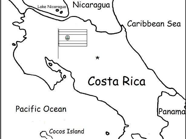
Introduce your students to Costa Rica with two worksheets (plus answer key). Your students will read a brief introduction to Costa Rica (location, capital, language, flag), write 'San José' next to the star on the map to show the location of the capital, color the small flag and map, and use the map and compass to answer 6 questions on page 2. Colored pencils and a pen or pencil are needed for this activity. No other prep needed. Basic Geography worksheet with a simple map to introduce Costa Rica and practice cardinal and ordinal directions.
For use with Interactive Notebooks: After the worksheets are completed, students can cut out the map and flag and paste into the notebook under the topic of Central America (or Spanish-Speaking Countries) /Sub-Topic: Costa Rica. Under the map and flag, students can write a summary in their own words of what they now know about this country. Collect worksheets for other countries of Central America (or Spanish-Speaking Countries) to add to the notebook! Worksheets for all countries available in this store! Please browse this store for a selection of printable Geography worksheets for other countries of Central America and beyond!
Thank you so much for using my Geography worksheets in your classroom! I hope you find them useful. Reviews are welcome and very much appreciated! Please browse this store for a selection of worksheets to introduce your learners to the countries of the world!
Introduce your learners to Panama with two printable worksheets (plus answer key). Your students will read a brief introduction to Panama (location, capital, flag, language), write ‘Panama City’ next to the star on the map to show the location of the capital, color the small flag and map, and use the map and compass to answer 10 questions on page 2. Colored pencils and a pen or pencil are needed for this activity. No other prep needed. Basic Geography worksheet with a simple map to introduce Panama and practice cardinal and ordinal directions.
For use with Interactive Notebooks: After the worksheets are completed, students can cut out the map and flag and paste into the notebook under the topic of (example): Central America or Spanish-Speaking Countries / Sub-Topic: Panama. Under the map and flag, students can write a summary in their own words about what they now know about this country. Collect worksheets for other countries of Central America (or Spanish-Speaking Countries) to add to the notebook! All available in this store! Please browse this store for worksheets for countries of Central America and beyond!
Thank you so much for using my Geography worksheets in your classroom! I hope you find them useful. Reviews are welcome and very much appreciated! Please browse this store for worksheets to introduce your learners to the countries of the world!
Key words: Panama canal, Spanish, cardinal, ordinal directions.
Introduce your students to the country of Slovenia in Europe with two worksheets (plus answer key). Your students will read a brief introduction to Slovenia (location, capital, flag, language), write Ljubljana next to the star on the map to show the location of the capital, color the small map, and use the map and compass to answer 9 questions on page 2. Colored pencils and a pen or pencil are needed for this activity. No other prep needed. Basic Geography worksheet with a simple map to introduce Slovenia and practice cardinal and ordinal directions.
For use with Interactive Notebooks: After completing the worksheets, students can cut out the map and flag and paste into the notebook under the topic of Europe/Sub-Topic: Slovenia. Under the map and flag, students can write a summary in their own words of what they now know about this country. Collect worksheets for other countries of Europe to add to the notebook! Please browse this store for a list of worksheets for other countries of Europe (and beyond!).
Thank you so much for using my Geography worksheets in your classroom! I hope you find them useful. Reviews are welcome and very much appreciated!
Introduce your students to the country of SENEGAL in West Africa with this printable handout of two worksheets (plus answer key). Your students will read a brief overview of Senegal (location, capital, flag, language), write ‘Dakar’ next to the star on the map to show the capital, write ‘Casamance’ in the area of Senegal south of The Gambia, color the small map, and use the map and compass to answer 10 questions on page 2. Colored pencils and a pen or pencil are needed for this activity. No other prep needed. Basic Geography worksheet with a simple map to introduce the country of Senegal and practice cardinal/ordinal directions.
For use with Interactive Notebooks: After the handout is completed, students can cut out the map and flag and paste into the notebook under the topic of Africa/Sub-topic: Senegal. Under the map and flag, your students can write a summary in their own words of what they now know about this country. Collect handouts for other countries of Africa to add to the notebook! Please browse this store for a selection of printable handouts for other countries of Africa (and beyond!).
Thank you so much for using my Geography worksheets in your classroom!
Introduce your students to the country of LESOTHO in Africa with two worksheets (plus answer key). Your students will read a brief introduction to Lesotho (location, capital, flag, language), write ‘Maseru’ next to the star on the map to show the location of the capital, trace the line of the Caledon River, color the small map, and use the map and compass to answer 6 multiple-choice questions on page 2. Colored pencils and a pen or pencil are needed for this activity. No other prep needed. Basic Geography worksheet with a simple map to introduce the country of Lesotho.
For use with Interactive Notebooks: After the worksheets are completed, students can cut out the map and flag and paste into the notebook under the topic of Africa/Sub-topic: Lesotho. Under the map and flag, your students can write a summary in their own words of what they now know about this country. Collect worksheets for other countries of Africa to add to the notebook! Please browse this store for a selection of printable handouts for all other countries of Africa (and beyond!)
Thank you so much for using my Geography worksheets in your classroom! I hope you find them useful. Reviews are welcome and very much appreciated!
Introduce your students to the country of LEBANON with this printable handout of two worksheets (plus answer key). Your students will read a brief introduction to Lebanon (location, capital, language, flag), write ‘Beirut’ next to the star on the map to show the capital, color the small map, and use the map and compass to answer 7 questions on page 2. Colored pencils and a pen or pencil are needed for this activity. No other prep needed. Basic Geography worksheet with a simple map to introduce Lebanon and practice cardinal/ordinal directions.
For use with Interactive Notebooks: After your students complete the handout, they can cut out the map and and flag and paste into the notebook under the topic of Asia (or Middle East) /Sub-topic: Lebanon. Under the map, your students can write a summary in their own words of what they now know about this country. Collect handouts for other countries of Asia or Middle East to add to the notebook! Please browse this store for a selection of printable handouts for other countries of Asia, the Middle East, and beyond!
Thank you so much for using my Geography worksheets in your classroom! I hope you find them useful. Reviews are welcome and very much appreciated! Please browse this store for more worksheets to use in your classroom!
Mediterranean Sea
Resource Room
Introduce your learners to the African Great Lakes with two printable worksheets (plus answer key). Simple map activity and reading comprehension questions. Your students will read a short passage about the African Great Lakes, trace the lines of each of the 9 Great Lakes on map 1 and color the lakes and surrounding countries. The African Great Lakes include: Lake Victoria, Lake Tanganyika, Lake Malawi, Lake Turkana, Lake Albert, Lake Edward, Lake Kivu, Lake Rukwa, and Lake Mweru. On map 2, a small map of Africa, place a blue dot to show the location of each of the 9 Great Lakes, then using the maps, answer 5 multiple choice questions on page 2.
Countries of the African Great Lakes Region included on this map: Uganda, Kenya, Tanzania, Malawi, the Democratic Republic of the Congo (DR Congo), Burundi and Rwanda. Also included on map: Mozambique, Zambia, Ethiopia and South Sudan.
If you’d like to introduce your learners to the 10 COUNTRIES of the African Great Lakes region, do so one country at a time with a printable worksheet for each country! Available individually or as a discounted bundle! Please click on this link for more info: https://www.tes.com/teaching-resource/african-great-lakes-region-countries-introductory-worksheets-bundle-12777435
Thank you so much for using my Geography worksheets in your classroom! I hope you find them useful. Reviews are welcome and very much appreciated. Please browse this store for a selection of printable Geography worksheets to introduce your students to the countries of the world!
Read some basic facts about the FLY and then answer 8 True/False questions. 2 printable worksheets plus answer key.
Facts included: The fly has two wings. They can fly up, down, side to side and even backwards; Flies have big eyes that can see in all directions at all times; Flies don’t have teeth. They have a long tongue that acts like a straw. They drink their food instead of eat it; Flies have sticky feet that can grip almost any surface. Their feet can taste food!; Flies have a lifespan of about one month. That is, unless a frog, bird or snake get to it first. Flies can be tasty meals for some critters!
Thank you so much for using my worksheets! I hope you find them useful. Please browse this store for a selection of printable worksheets! :)
Introduce your learners to the U.S. state of WASHINGTON with two worksheets (plus answer key). Your students will read a brief introduction to Washington (location, capital, flag, state bird, state flower), write ‘Olympia’ next to the star on the map to show the capital, color the small map, state bird (American Goldfinch) and state bird (Rhododendron), and use the map and compass to answer 9 questions on page 2. Colored pencils and a pen or pencil are needed for this activity. No other prep needed. Basic Geography worksheet with a simple map to introduce the state of Washington and practice cardinal and ordinal directions.
For use with Interactive Notebooks: After the worksheets are completed, students can cut out the map, flag, state bird and state flower, and paste into the notebook under the topic of United States/Sub-Topic: Washington. Under the map, students can write a summary in their own words of what they now know about this state. Collect worksheets for all U.S. states to add to notebook! Please browse this store for a selection of printable Geography worksheets for all 50 states of the USA!
Thank you so much for using my Geography worksheets in your classroom. I hope you find them useful. Reviews are welcome and very much appreciated.
Included on map: Oregon, Idaho, Canada, Pacific Ocean, Seattle, State Seal.
Introduce your learners to Washington D.C. - the capital of the United States of America, with this printable handout of two worksheets (plus answer key). Your students will read a brief overview of Washington D.C., write ‘White House’ next to the star on the map to show the location of the White House, color the small map, and answer 8 True/False questions on page 2. Colored pencils and a pen or pencil are needed for this activity. No other prep needed. Basic Geography worksheet with a simple map to introduce Washington D.C.
For use with Interactive Notebooks: After the worksheets are completed, students can cut out the map and flag of Washington D.C. and paste into the notebook under the topic of United States / Sub-Topic: Washington D.C… Under the map, students can write a summary in their own words of what they now know about Washington D.C. Collect worksheets for all U.S. states to add to notebook! Please browse this store for a selection of printable Geography worksheets for all states of the USA (and beyond!).
Thank you so much for using my Geography worksheets in your classroom! I hope you find them useful. Reviews are welcome and very much appreciated.
District of Colombia, Potomac River, Virginia, Maryland. State Bird and State Flower. Wood Thrush. American Beauty Rose
Introduce your learners to the country of Yemen with this printable handout of two worksheets (plus answer key). Your students will read a brief introduction to Yemen (location, capital, language, flag), write ‘Sana’a’ next to the star on the map to show the capital (Aden declared as the temporary capital in 2015), color the small map, and use the map and compass to answer 6 multiple-choice questions on page 2. Colored pencils and a pen or pencil are needed for this activity. No other prep needed. Basic Geography worksheet with a simple map to introduce Yemen and practice cardinal/ordinal directions.
For use with Interactive Notebooks: After your students complete the worksheets, they can cut out the map and flag and paste into the notebook under the topic of Asia or Middle East / Sub-topic: Yemen. Under the map, students can write a summary in their own words of what they now know about this country. Collect worksheets for other countries of Asia or Middle East to add to the notebook! All available in this store! Please browse this store for a selection of printable worksheets for other countries of the Middle East and Asia (and beyond!)
Thank you so much for using my Geography worksheets in your classroom! I hope you find them useful. Reviews are welcome and very much appreciated!
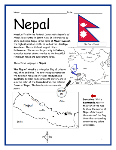
Introduce your learners to the country of Nepal in Asia with this printable handout of two worksheets (plus answer key). Your students will read a brief introduction to Nepal (location, capital, language, flag), write ‘Kathmandu’ next to the star on the map to show the location of the capital, color the small map, and use the map and compass to answer 8 multiple-choice questions on page 2. Colored pencils and a pen or pencil are needed for this activity. No other prep needed. Basic Geography worksheet with a simple map to introduce Nepal and practice cardinal/ordinal directions.
For use with Interactive Notebooks: After your students complete the worksheets, they can cut out the map and flag and paste into the notebook under the topic of Asia / Sub-topic: Nepal. Under the map, students can write a summary in their own words of what they now know about this country. Collect worksheets for other countries of Asia to add to the notebook! Please browse this store for a selection of printable worksheets for other countries of Asia (and beyond!).
Thank you for using my Geography worksheets in your classroom! I hope you find them useful. Reviews are welcome and very much appreciated!
Included: China, India, Mount Everest, Himalayas, Pokhara, Rhododendron
Introduce your learners to the island country of JAMAICA with this printable handout of 2 worksheets (plus answer key). Your students will read a brief introduction to Jamaica (location, capital, flag), write ‘Kingston’ next to the star on the map to show the location of the capital, color the maps, and use the maps and compass to answer 10 true/false questions on page 2. Colored pencils and a pen or pencil are needed for this activity. No other prep needed. Basic Geography worksheet with simple maps to introduce the country of Jamaica and practice cardinal and ordinal directions.
For use with Interactive Notebooks: After the worksheets are completed, students can cut out the map and flag and paste into the notebook (under the topic of the Caribbean or West Indies or Greater Antilles / Sub-topic: Jamaica). Under the map, your students can write a summary in their own words of what they now know about this country. Collect worksheets of other countries to add to the notebook! Please browse this store for a selection of worksheets for other countries of the Caribbean (and beyond!).
Thank you so much for using my Geography worksheets in your classroom! Reviews are welcome and very much appreciated.
Caribbean Sea, Cuba, Hispaniola, Dominican Republic, Haiti, Cayman Islands, Montego Bay, Negril, Port Antonio, Blue Mountain, Blue Mountain Peak.
Printable Handout (1 page plus answer key) ‘A Summer Day at the Beach.’ Students will fill in the blanks using the word bank of past-tense verbs: parked, swam, collected, drove, decided, watched, walked, sat, read, ate, packed, carried.
Cloze activity for ESL, EFL, ELL, ESOL. Vocabulary building, Reading Comprehension, Grammar.
Introduce your students to Guatemala with two printable worksheets (plus answer key). Your students will read a brief introduction to Guatemala (location, capital, flag, language), write ‘Guatemala City’ next to the star on the map to show the location of the capital, color the small flag and map, and use the map and compass to answer 7 questions on page 2. Colored pencils and a pen or pencil are needed for this activity. No other prep needed. Basic Geography worksheet with a simple map to introduce Guatemala and practice cardinal and ordinal directions.
For use with Interactive Notebooks: After the worksheets are completed, students can cut out the map and flag and paste into the notebook under the topic of Central America (or Spanish-Speaking Countries)/ Sub-Topic: Guatemala. Under the map and flag, students can write a summary in their own words about what they now know about this country. Collect worksheets for other countries to add to the notebook! Please browse this store for worksheets for other countries of Central America and beyond!!
Thank you so much for using my Geography worksheets in your classroom! I hope you find them useful. Reviews are welcome and very much appreciated. Please browse this store for worksheets to introduce your students to the countries of the world!
Libertad 15 de Septiembre de 1821, cardinal, ordinal directions, Spanish, Mexico, Belize, Honduras, El Salvador, Caribbean Sea, Pacific Ocean.
Introduce your learners to the Bahamas with two worksheets (plus answer key). Your students will read a brief introduction to the Bahamas (location, capital, flag, islands), write ‘Nassau’ next to the star on the map on New Providence to show the location of the capital, color the map, and use the map and compass to answer 8 true/false questions on page 2. Colored pencils and a pen or pencil are needed for this activity. No other prep needed. Basic Geography worksheet with a simple map to introduce the Bahamas and practice cardinal and ordinal directions.
For use with Interactive Notebooks: After the worksheets are completed, students can cut out the map and flag and paste into the notebook under the topic of (example) Countries of the World / Sub-topic: The Bahamas. Under the map, your students can write a summary in their own words of what they now know about the Bahamas. Collect worksheets of other countries to add to the notebook! Please browse this store for a selection of worksheets to introduce your learners to countries of the Caribbean and around the world. :)
Thank you so much for using my Geography worksheets in your classroom! I hope you find them useful! Reviews are welcome and very much appreciated.
Introduce your students to the country of SAN MARINO with two worksheets (plus answer key). Your students will read a brief introduction to San Marino (location, capital, flag, language), write ‘City of San Marino’ next to the star on the map to show the location of the capital, color the small map, and use the map and compass to answer 6 multiple-choice questions on page 2. Colored pencils and a pen or pencil are needed for this activity. No other prep needed. Basic Geography worksheet with a simple map to introduce the country of San Marino and practice cardinal and ordinal directions.
For use with Interactive Notebooks: After completing the worksheets, students can cut out the map and flag and paste into the notebook under the topic of Europe/Sub-Topic: San Marino. Under the map and flag, students can write a summary in their own words of what they now know about this country. Collect worksheets for other countries of Europe to add to the notebook! Please browse this store for the list of worksheets for other countries of Europe (and beyond!).
Thank you so much for using my Geography worksheets in your classroom! I hope you find them useful. Reviews are welcome and very much appreciated.